
|
|
||
|
|
BIBLIOGRAPHY: Austin American-Statesman, July 16, 1989. Joan Druesedow Griggs, Fifty Years of Glory: the Old Glory School as an Assimilation Factor in the Community (M.A. thesis, West Texas State University, 1982). A History of Stonewall County (Aspermont, Texas: Stonewall County Historical Commission, 1979). Joan Druesedow Griggs MONTEREY, TEXAS (Lubbock County). The brief history of Monterey began in the summer of 1890, when the town was established by W. A. Rayner, a cattleman and town promoter. Rayner had previously organized the town of Rayner to be the county seat of Stonewall County, and he hoped to repeat his success on the South Plains. By July 1890 he and three associates, W. D. Crump,qv H. M. Bandy, and D. F. Goss, had found a suitable site for a town on the north side of Yellow House Canyon in Lubbock County. But Rayner soon insisted on building on the south side of the canyon, assuming that trade routes and a possible railroad line could more readily reach that side. The group split over the issue, and Rayner alone established Monterey, sometimes called South Town or Ray Town, on August 6, 1890. The northern contingent, aided by Rollie Burns, Frank Wheelock,qqv and others, established the town of Lubbock by August 12, 1890. Although a rivalry soon developed over which town would become the county seat, representatives from the two factions met that winter to effect a compromise. In an accord voted on December 19 they agreed to retain the name Lubbock, select a new townsite, consolidate the two towns, move buildings and houses to the new location, and organize a government. At the time of the merger Monterey had a population of fifty and thirty-two buildings. The original site of Monterey was north of the present campus of Texas Tech University. BIBLIOGRAPHY: Seymour V. Connor, "The Founding of Lubbock," in A History of Lubbock, ed. Lawrence L. Graves (Lubbock: West Texas Museum Association, 1962). Charles G. Davis Stonewall County History Except for Coronado's 1540/41 expedition, the region encompassing what is now Stonewall county was largely unmapped and uninhabited until the late 17th century, when the Plains tribes, primarily the Comanche - forever changed by the adoption of the horse into their culture - moved southward onto and through the rolling plains of Texas, and it became part of the Comancheria. For the next nearly 200 years, no matter what the citizens and governments of provincial Texas, colonial Texas, the Republic of Texas, the United States, or the Confederate States may have believed, it was in reality these "Lords of the Plains", who ruled this part of Texas. Coronado's report made intriguing mention of copper mines in the Double Mountain area, and suggested the possibility of even more precious minerals. In 1786, Domingo Cabello, governor of the province of Texas, commissioned Pedro Vial to explore the region. Another exploratory expedition was undertaken by Jose Mares in 1788. After statehood, Randolph B. Marcy led an exploratory and surveying expedition in 1849. The Double Mountains, one of the county's most recognizable natural features, are mentioned in his log as "...two low bald mountains in sight which are good land marks". Unlike the other southern states, Texas had never gone through a territorial phase, prior to annexation. Land ownership in the western rolling plains area of Texas dates to the 1850's, although significant Anglo settlement did not actually commence for another 20 years. In 1845, that area of Texas which is roughly west of the 98th meridian, and north of the 30th parallel, was still a vast, uncharted area, demarcated on maps only by notations of Comanche and herds of wild Mustangs. Climate, geography, and hostile Indians had been incentive enough to keep the colonials coming north from Mexico, and west from the US, well south and east of the Comancheria. Securing even marginal safety of the sporadic settlements on or near that line of settlement (and along the border, after 1836) required the most rigorous and diligent efforts of the legendary Texas Rangers. Annexation brought only a deterioration in relations with the Indians. Between 1845 and 1860 the diplomatic policy of the federal government, (which was far more experienced at dealing with the "Five Civilized Tribes", who were quite different from the Comanche) toward the Plains Tribes was one of relative appeasement. The federal policy-makers deemed negotiation preferable to combat, though there was no shortage of the latter. This passive stance did not sit well with most Texans, who were somewhat understandably biased by a generation of frequent and appalling depredations on their settlements. As Secretary of War in the mid-1850's, Jefferson Davis, who understood the unique nature of the problem in Texas better than most, made one of the more realistic and valiant attempts to deal with the problems on the Texas frontier. Davis managed to convince the state of Texas to set aside land for the tribes willing to stay on reservations, and sent the formidable 2nd U.S. Cavalry to protect the Texas frontier, including future Confederate Generals Robert E. Lee, John Bell Hood, Lawrence S. (Sul) Ross, and Albert Sidney Johnston. (Davis would later be accused of using the Texas frontier as a "proving ground" for CSA officers-to-be, but there was no shortage of future federal officers on the frontier, too). Their determined efforts managed at best to hold the line of settlement, not advance it. Depredations continued, and the failure of the United States to protect the frontier settlements, as well as those along the Mexican border, is mentioned in Texas' 1861 Ordinance of Secession. During the War Between the States, salt was mined from the Salt Fork of the Brazos at the "Double Mountain Salt Works" in neighboring Kent county, the northern-most industry in Confederate Texas. The historical marker commemorating this endeavor mentions the dangers involved in an extended stay beyond the line of settlement, and how rigorously the Salt Works had to be defended. The CSA could ill-afford to expend any man-power guarding frontier settlements, and recommended that all people living on or beyond the line of settlement "fort up" for the duration of the War. Sage advice, for during the War years, in spite of treaties and negotiations with both the CSA and the USA, the Indians, Comanche in particular, took full advantage of the relatively defenseless Texas frontier.
During the Civil War, the Indians, unrestrained
by the United States Army, held carnival across the plains - north to
south and east to west - looting, pillaging, and marauding over a wide
area...Colonization receded; homes and fields were abandoned in north
central Texas and settlers were withdrawn for over a hundred miles.
"The frontier was scourged as never before in
its history. In some places the line of settlements was driven back a
hundred miles." Whatever else the War changed, it altered the fundamental conflict between the Southern Plains tribes, and Anglo settlement not at all, and its aftermath only served to exacerbate the situation. The devastation and upheaval in other areas of the south, and a desire to escape the most oppressive aspects of living in an occupied country by emigrating to a less populous area, brought more settlers than ever toward the Texas frontier. In response to this increased threat to land they had held for over 200 years, the Indian depredations became increasingly flagrant and deadly. When the U.S. Army returned to Texas in 1865 for "reconstruction", they came to occupy the state, not defend it. During the latter half of the 1860's the raids continued unabated, and were met with public outcry, but minimal military response. By the early 1870's, it was most apparent that the policy coupling appeasement and voluntary relocation to the reservations in Oklahoma Territory was never going to subdue the Plains Tribes. Instead of attempting any sort of equitable settlement with them, something which many leaders of both sides thought impossible, the U.S. Army brought in Capt. Ranald S. Mackenzie, and the final, epic, Indian War of Texas commenced. The Plains tribes were highly dependent on the buffalo for food, clothing, et al. Believing that it was the only way to once, and forever, resolve the "Indian problem"; with not only the support, but encouragement of the regional military authorities in the forms of the infamous Generals William T. Sherman and Philip Sheridan; over the objections of several members of the state legislature; and in abrogation of the 1867 Treaty of Medicine Lodge, a tacit policy of support for the eradication of the buffalo evolved. Buffalo hunters swarmed onto the plains. Crude, ramshackle communities sprang up around the frontier forts, attracting transient "settlers" of questionable repute, and the entrepreneurs eager to pander to their needs, contributing in no small part to the contemporary stereotype of the "wild west". One such community was Rath City, about 10 miles south of what is now Aspermont, established by veteran entrepreneur Charles Rath of Kansas, who was already capitalizing on the buffalo hide trade in that state. In a very few short years, the American bison was hunted to the brink of extinction. At the southern end of the plains, while the hunters decimated the buffalo, Capt. Mackenzie and his troops regularly engaged the tribes in combat. Mackenzie's expedition located a path through the staked plains, once used by Coronado, and notable for the relative frequency and dependability of watering holes, which enabled them to follow their quarry up onto the staked plains (llano estacado), well past the point where previous expeditions had turned back. In a rare show of unity, the plains tribes, led by Quanah Parker of the Quahadi Comanche band, forged an alliance to drive back the buffalo hunters and the U.S. Army. Their unity ended, and the fate of their people was decided, after an unsuccessful attack on an encampment of buffalo hunters at Adobe Walls, June 27, 1874. Three months later, September 28, 1874, Mackenzie located the Quahadi in Palo Duro canyon, and carried out the order to rid the southern frontier of the Comanche threat.
"The shrieking animals were shot down in a
thunderous roar of firing, more shooting than had been done in Palo Duro.
For years afterward , thousands of horse bones lay whitening here, a
stark monument on the Plains." The Army struck at dawn, surprising the Comanche in their teepees. The braves were able to mount a resistance and hold the Army back long enough for the women and children to get away, then followed them. They were able to take nothing with them. Mackenzie ordered that everything that they had left behind be burned. Sgt. Charlton had captured the Comanche's remuda (horse herd), and taken it to Tule Canyon. The Army could not manage the horses, but realized that they could not afford for them to return to Comanche hands, so over 1000 of what may have been some of the finest horses ever bred, combinations of stolen pedigreed stock and Spanish Mustangs, were brutally destroyed that day. It was the loss of their horses, more than anything else, that put an end to the Comanche's reign as the "Lords of the Plains". The starving and dismounted Quahadi held out for another eight months, surviving on sheer will, and Mackenzie continued his dogged pursuit, but the war was over that September morning - bringing to a sad end what had arguably been the most tragic decade in Texas history, and removing the last impediment to Anglo settlement and civilization of the Texas plains. Two years after that decisive battle, on August 21, 1876, Stonewall was one of the many counties that the 19th Texas Legislature carved from the dearly won rolling plains and llano estacado (former Bexar and Young land Districts). It was named for Confederate General Thomas J. "Stonewall" Jackson. For twelve years, the county was attached to Young, and then Jones county for judicial and administrative purposes. In November of 1888 the citizens petitioned the Jones County Commissioner's Court to be allowed to set up their own government, and the first county election was held the folloing month. The first county seat was Rayner (1888-1890). After quite a battle, and a veritable tug-of-war over records and furnishings, it was moved to Aspermont in 1890, where it remains. (Unfortunately, the lovely, late Victorian courthouse in Aspermont had to be replaced in 1983). The first recorded deed transaction for land within the eventual county boundary was on 01April1856, when the General Land Office issued sixteen Certificates of Land script to the Buffalo Bayou, Brazos, & Colorado Railroad (BBB&C). This entitled the BBB&C to a section (640 acres) of land along the Double Mountain Fork of the Brazos. After changing hands several times, this section came back into possession of the BBB&C, and was sold to S.M. Swenson on 02March1879, the foundation of the Swenson ranch, which still exists. Several other RR companies were issued script within the eventual county boundaries. The first recorded transfer of land to an individual was 250 acres to Martindale Daniel in 1870. In 1881 nine individuals were deeded a section of land each, among them, A.H. Rhomberg, and wife Mattie. The "Latinization" of Mr. Rhomberg's name (to Aspermont) would eventually become the name of the largest town, and present county seat. Transfer or sale of smaller tracts of land did not become common until the mid-1890's. Most of the early land transactions were homestead preemptions, whereby the land would be deeded over to an individual who lived on it for three years, or "school land" purchases, which sold for $1.00 per acre. The first large group of settlers came to Stonewall county in 1885, probably brought by county surveyor C.P. Benson. By 1890, the county population was 1,024. Enough settlement had occurred in the late 1880's to necessitate an end to the open range, a ranching tradition eschewing fences that dated back to the early years of Spanish Texas. The Swenson ranch put up the first fence (four-wire) in the county in 1888. There is no record of "fence-cutting" being a problem in Stonewall county, but it was common in other areas of Texas, where the cattlemen and trail-drivers had a strong interest in preserving the open range tradition. Stonewall county grew quickly, doubling its population between census years, until 1920, when apparently WWI, and a mid-decade dip in the prices of cotton, wheat, cattle, and other commodities may have contributed to the loss of approximately 20% of the 1910 population. If these decennial census figures are any indication, Stonewall county did not experience the degree of emigration during the tragic "Dust Bowl" years that some of its neighboring counties, and much of the Great Plains "farm belt" did. Income from oil and gas exploration and recovery may have had a buffering during the years of drought and economic depression. The county population peaked at 5,668 in 1930, and was scarcely 200 fewer in 1940. The population is less than half of that now, but the bulk of that loss has occurred in the years after WWII, which have been characterized by the dwindling of the small farmer/rancher as a major economic entity in the U.S. (For more information on county and regional history, the Southern Plains Tribes, ranching, dryland farming, etc., see "Links" on the Kent County Main Page.) (Sources include, _Lone Star: A History of Texas and Texans_, 1968, T.R. Fehrenbach; _Stonewall County: Between the Forks of the Brazos_, 1979, Stonewall County Historical Commission; and _The 1994/95 Texas Almanac_ comp. by The Dallas Morning News)
STONEWALL COUNTY. Stonewall County (C-12) is in Northwest Texas, in the central part of the North Central Plains and southeast of the Caprock. It is bounded on the north by King County, on the east by Haskell County, on the south by Fisher and Jones counties, and on the west by Kent County. The center of the county lies at approximately 33012' north latitude and 100015' west longitude. Aspermont, the county seat, is just southwest of the county's center and sixty miles north-northwest of Abilene. The county was named for Confederate general Thomas J. (Stonewall) Jackson. It encompasses 926 square miles of the Rolling Plains region of Texas. Its soils range from neutral to slightly alkaline, calcareous sandy loams of dark brown to reddish brown color in the western part, to clay and clay loams in the east. These soils generally support mesquite savanna or bunchgrass, short grasses, and mesquite. Cedar, hackberry, cottonwood, chinaberry, and shin oak trees are also found in the county. The average annual precipitation is 22.36 inches. Temperatures range from an average minimum of 300 F in January to an average maximum of 990 in July. The average growing season lasts 220 days. The county is framed by two forks of the Brazos River. The Salt Fork crosses the northern half, while the Double Mountain Fork flows near the southern boundary, turns to the north, and joins the Salt Fork after curving through western Haskell County. There are also many tributaries, such as Tonk and Croton creeks, which contribute to the rough, broken country. The county's topography varies from rolling plains to mountainous terrain, with 50 to 80 percent of the area gently sloping. Elevations range from 1,500 to 2,400 feet, the latter being the elevation of Double Mountain, one of the outstanding geographical features of the county. Kiowa Peak, in the northeastern corner, and Flat Top Mountain in the southeast were important landmarks to Indians and later to early explorers who traversed the area. In 1982, 94 per cent of the county's land was in farms and ranches; about 52 percent of its agricultural income was derived from crops, especially wheat, cotton, oats, sorghum, hay, and peanuts. Cattle and livestock products are also important to the local economy, and there is large-scale ranching over much of the county, especially the southern part. Mineral resources include gypsum, sand, gravel, petroleum, and natural gas. The county's main transportation routes are U.S. Highway 83, which runs north to south through the center of the county, and U.S. Highway 380, which crosses from east to west. Indians that roamed the area included the nomadic Comanches, Kiowas, and Tonkawas. Their names remain on such landmarks as Kiowa Peak and Tonk Creek. Early explorers Jose Mares and Pedro Vial traveled through the area during the eighteenth century. Mares apparently wintered on the Double Mountain Fork in February 1788 on his trip for the Spanish governor of New Mexico. The following year Vial also probably followed the Double Mountain Fork for several days as his party advanced westward from Bexar to Santa Fe. In advance of the westward migration of the nineteenth century, Capt. Randolph Barnes Marcyqv led an expedition to open a route through Indian Territory. On October 12, 1849, he camped by the Double Mountain Fork during a norther. In 1854 Marcy was selected to explore the Texas frontier for the purpose of locating suitable sites for Indian reservations. On this trip he passed through the northeastern part of the county near Kiowa Peak, crossed the Salt Fork on the eastern edge, and continued over a valley toward Flat Top Mountain, which he recognized from his previous trip in 1849. An Indian reservation that Marcy helped to locate failed to eliminate the devastation the Comanches and Kiowas continued to inflict upon the white settlers along the Texas frontier. In an effort to stop the raids, in 1871 Col. Ranald Slidell Mackenzieqv led a force of cavalry against the Indians in the area. In 1872 Miner K. Kellogg became the first artist to represent pictorially the country beyond the Brazos. He accompanied the Texas Land and Copper Association's expedition to Texas to survey, explore, and locate land for the company; the expedition made trips to Kiowa Peak and Double Mountain in search of copper. In addition to his sketches Kellogg also wrote descriptions of the topography and vegetation of the region. Cattlemen soon started moving herds into the vast sections of open grassland. The first ranch in the future county was probably established by buffalo hunter John Goff, who grazed 200 heifers on Tonk Creek in the winter of 1873. Later, in 1877, One-Armed Jim (James D.) Reed and his son Paul, of Goliad County, brought in 3,000 longhorn cattle and established the Double Mountain Horseshoe T Cross Ranch on Tonk Creek. Reed built a large stone house for his residence, but it was also designed to serve as a fort against renegade Indians. In late December 1876, Charles Rath of Kansas blazed the Rath Trail from Dodge City to the Double Mountain Fork and established Rath City, a buffalo hunters' supply camp located a little east and south of Double Mountain and one mile north of the Fisher county line. Although Rath had hideyards in several other locations, Rath City was reputedly the greatest yard of all, where long ricks of hides were stacked ready to be hauled to market. The mail was taken to Rath City from Fort Griffin twice a week by cowboys riding relays. When the buffalo were gone after the great slaughter, the need for the trading post ceased, and the accumulated ricks of buffalo hides were moved to Fort Worth in April 1879. Stonewall was one of fifty-four counties formed by the Fifteenth Texas Legislature in 1876 from the Young and Bexar districts. It remained attached to Young County for judicial and all other governmental purposes until March 31, 1887, when it was attached to Jones County for convenience. Stonewall County was still unorganized in 1880, when the census found 104 people, including 91 whites, 10 blacks, and 3 Indians, living there. Settlers moved to the county in increasing numbers during the 1880s. At first they settled a few miles south of the site of the present county seat, but they eventually spread to the west and northeast. About the same time, ten families settled on the east side of the county and established the community of Hooker. In 1888 the residents of the county petitioned the Jones County Commissioners Court to hold an election for the organization of the county. The balloting took place on December 20 of that year. However, the question of the county seat had been omitted from the ballot. On June 12, 1889, W. E. Rayner granted land for a townsite, and the new town of Rayner became the county seat. The courthouse, a large stone building, was built the following year. By 1890 there were 1,024 people living in the county. The agricultural census for that year found 144 farms there, encompassing more than 23,000 acres, 6,758 acres of which was classified as "improved." The cattle industry dominated the local economy. Only 719 acres was planted in corn, the county's most important crop at that time, while the agricultural census reported 5,023 cattle and 5,203 sheep. As the county's population continued to expand in the 1890s, the placement of the county seat became a source of local controversy. A. L. Rhomberg had secured a patent in February of 1889 and platted a town, Aspermont, which was closer than Rayner to the center of the county. Beginning in 1892 the citizens of Aspermont made several attempts to make their rapidly growing town the county seat, and finally succeeded after an election held in June 1898. The controversy did not really end, however, until March 1900, when a contract to build a new courthouse in Aspermont was signed. Rayner soon ceased to exist. Legends of buried treasure, Spanish missions, and gold and silver mines had led to many explorations for ore along the Salt Fork of the Brazos. In the late 1890s a tent town, later known as Orient, was started by workers at the Orient copper mines. The town grew quickly after false claims of a silver strike, but both the copper and gold mines were closed after a very short period of operation, having yielded no riches. By 1900 the population of Stonewall County had increased to 1,024 and crop farming was beginning to become established in the area. There were 381 farms and ranches in the county that year. More than 4,000 acres planted with corn produced more than 106,000 bushels; 3,800 acres planted with cotton produced 804 bales. Smaller crops of wheat and oats were also grown in the area. Cattle ranching dominated the county's economy and culture in 1900, however, when almost 37,000 cattle were reported in Stonewall County. Settlement of the county intensified early in the 1900s, encouraged by railroad construction that helped to ease immigration and to tie the area to national markets. The Kansas City, Mexico and Orient Railway built across the southeastern corner of the state in 1904, and the Stamford and Northwestern line crossed the county in 1909. A number of new communities sprang up in the area. In 1904 a group of German families moved into the eastern side of the county, bought unbroken land north of the Double Mountain Fork, and established the town of Brandenburg, which was renamed Old Glory in 1918. Brandenburg was moved two miles to the west when the Stamford and Northwestern Railway built into the county; other communities also moved to meet the railroad at new townsites. Much of the area's growth during this time was influenced by the S. M. Swenson and Sons ranching operation, which later became the Swenson Land and Cattle Company. The Swensons, who controlled a great deal of land in the area, helped to establish at least two towns, including the one that carries their name. The first three decades of the twentieth century saw the firm establishment of crop farming in the county, as cotton culture continued to expand for most of this period. More than 21,000 acres in the county was planted in cotton by 1910, almost 29,000 acres by 1920, almost 45,000 acres by 1925, and more than 67,000 acres by 1929. Though the population generally rose during this period, the difficulties of dry-land farming drove out some of the new farmers. The number of people living in the county rose to 5,320 by 1910, when there were 834 farms in the area, but dropped to 4,086 by 1920, when only 575 farms remained. Nevertheless, in 1918 the county had thirty-five communities with school districts, and the population began to grow again in the 1920s. By 1930 the county had 894 farms and ranches encompassing 454,000 acres and a population of 5,667. Though ranching declined during the early twentieth century as farmers moved in, cattle remained important to the local economy. In 1930 the agricultural census reported more than 20,000 cattle in the county. Many of the county's farmers were ruined during the hard years of the Great Depression. Cotton acreage dropped almost 45 percent between 1930 and 1940; by the latter year cotton was planted on only about 37,000 acres in the county. Total cropland harvested in the county declined from almost 96,000 acres in 1930 to just over 77,000 acres in 1940. By that year, only 754 farms remained in the county. During the early 1930s many communities also lost part of their local autonomy. New school laws and improved transportation led to the consolidation of the area's schools into three districts centered in Peacock, Aspermont, and Old Glory. The county's population declined to 5,589 by 1940, and the drop might have been more severe if modest oil production had not begun in the county in 1938. By 1940 the railroads that had once served the area were all gone except for the Atchison, Topeka and Santa Fe (formerly the Kansas City, Mexico, and Orient), which barely crossed the southeast corner of the county. Stonewall County's population dropped significantly during the 1940s, 1950s, and 1960s, as mechanized farm techniques contributed to the consolidation of farmlands and young people moved to urban areas in search of economic opportunities. Only 447 farms remained in the county in 1969, and only 338 in 1978. The population declined to 3,679 by 1950, 3,017 by 1960, and 2,397 by 1970; the number of residents increased only slightly during the 1970s, to reach 2,406 by 1980. The smaller towns were steadily depopulated during this period. In 1940 Aspermont had 1,041 residents, Swenson approximately 400, Old Glory about 250, and Peacock 216. More than 3,000 people lived on farms in the county. By 1980 Swenson had 185 residents, while Old Glory and Peacock each counted only 125. Meanwhile Aspermont, the county seat, had grown to a population of 1,357. The county's decline occurred in spite of significant petroleum and gas production in Stonewall County during the post-World War II period. Though oil had begun to be produced in the county in 1938, as late as 1948 production totaled only about 18,000 barrels. By 1956, however, the county's oil production had jumped to almost 10,254,000 barrels. Though production declined in later years, oil helped to stabilize and diversify the local economy. Stonewall County wells produced more than 6,217,000 barrels of petroleum in 1960, almost 5,460,000 barrels in 1974, more than 4,428,000 barrels in 1978, more than 4,423,000 barrels in 1982, and more than 6,018,000 barrels in 1990. By January 1, 1991, almost 226,089,000 barrels of crude had been pumped from Stonewall County land since discovery in 1938. County voters supported Democratic candidates in virtually every presidential election between 1892 and 1988. The only exception occurred in 1972, when Stonewall County voters gave Republican Richard Nixon a majority over Democrat George McGovern. In 1992 a plurality of the county's voters supported Democrat William J. Clinton over Republican George Bush and independent Ross Perot. In 1990, 2,284 people lived in Stonewall County. Aspermont (1990 population, 1,299) remained the county seat as well as the commercial center for ranching, farming, and petroleum operations, while Old Glory (125) was the center of the ranching operations in the eastern section. The Stonewall County Fair is held in Aspermont each June, and the Aspermont Township Homecoming is held there in October. BIBLIOGRAPHY: Llerena B. Friend, ed., M. K. Kellogg's Texas Journal: 1872 (Austin: University of Texas Press, 1967). A History of Stonewall County (Aspermont, Texas: Stonewall County Historical Commission, 1979). George Dewey Railsback, History of Stonewall County (M.A. thesis, Hardin-Simmons University, 1940). Joan Druesedow Griggs
RAYNER and ASPERMONT The town of Rayner was platted
in 1889 just after it became the first county seat of Stonewall County.
After two elections in 1898, the county seat was moved to Aspermont. About Stonewall County Double
Mountain is the most notable landmark within Stonewall County. Double
Mountain rises to a height of 600 feet above the surrounding area and is
approximately 2,500 feet above sea level, and the mountains can be seen
as far away as 25 miles. It is a barrier where the Brazos River has to
fork around the mysterious geologic site. Rayner: Texas Ghost Town
|
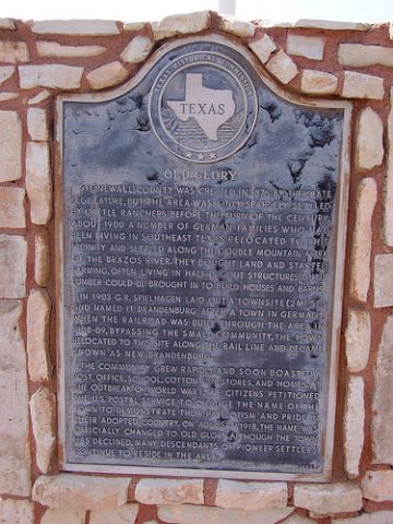 OLD GLORY, TEXAS. Old Glory is on U.S. Highway 380
between the Double Mountain Fork and the Salt Fork of the Brazos River,
five miles from the Haskell county line in eastern Stonewall County.
Development began with a few ranches and scattered farms in the late
1880s. By 1904 a group of German Americans had settled east of what is
now the townsite of Old Glory. They laid out the site for the town of
Brandenburg, but only a schoolhouse and a general store were
constructed. Other families continued to move into the area northwest of
Brandenburg. In 1909 the Stamford and Northwestern Railway Company was
chartered to build a railroad from Stamford to Spur. The Swenson Land
and Cattle Company provided a townsite on the rail line two miles west
of the original Brandenburg site. The name of the new town became New
Brandenburg, or simply Brandenburg, and the old community then became
known as Old Brandenburg. The new town grew with the coming of the
railroad, and a mercantile store, a gin, and a post office soon served
the community. A one-room school was constructed. At the beginning of
World War Iqv there was strong sentiment to change the name
of the town, and residents chose the name Old Glory, which became
official in 1918. The community's growth continued through the 1920s,
and its population reached a peak of 275 in 1929. Its population dropped
to around seventy-five during the Great Depressionqv but rose
to about 250 by the early 1940s. With the consolidation of five local
community schools, a building was erected at Old Glory in 1930 to serve
an enrollment that peaked at 280 in 1936-37. The school stood at the
center of activities within the community, serving as a civic center as
well as an educational institution. The town's population dropped to 175
by the late 1940s, and the drought of the early 1950s forced many people
out of work. In the late 1950s and early 1960s Old Glory enjoyed a small
boom, perhaps as a result of the development at that time of oil
resources in Stonewall County. The town's population was reported as 250
by 1965. By 1973, however, the town's population was estimated at only
125. Though the Texas Almanacqv reported Old Glory's
1990 population was still 125, a 1989 newspaper report put its
population at about sixty. At that time the community still had its post
office, as well as a church and a combination gas station and grocery
store.
OLD GLORY, TEXAS. Old Glory is on U.S. Highway 380
between the Double Mountain Fork and the Salt Fork of the Brazos River,
five miles from the Haskell county line in eastern Stonewall County.
Development began with a few ranches and scattered farms in the late
1880s. By 1904 a group of German Americans had settled east of what is
now the townsite of Old Glory. They laid out the site for the town of
Brandenburg, but only a schoolhouse and a general store were
constructed. Other families continued to move into the area northwest of
Brandenburg. In 1909 the Stamford and Northwestern Railway Company was
chartered to build a railroad from Stamford to Spur. The Swenson Land
and Cattle Company provided a townsite on the rail line two miles west
of the original Brandenburg site. The name of the new town became New
Brandenburg, or simply Brandenburg, and the old community then became
known as Old Brandenburg. The new town grew with the coming of the
railroad, and a mercantile store, a gin, and a post office soon served
the community. A one-room school was constructed. At the beginning of
World War Iqv there was strong sentiment to change the name
of the town, and residents chose the name Old Glory, which became
official in 1918. The community's growth continued through the 1920s,
and its population reached a peak of 275 in 1929. Its population dropped
to around seventy-five during the Great Depressionqv but rose
to about 250 by the early 1940s. With the consolidation of five local
community schools, a building was erected at Old Glory in 1930 to serve
an enrollment that peaked at 280 in 1936-37. The school stood at the
center of activities within the community, serving as a civic center as
well as an educational institution. The town's population dropped to 175
by the late 1940s, and the drought of the early 1950s forced many people
out of work. In the late 1950s and early 1960s Old Glory enjoyed a small
boom, perhaps as a result of the development at that time of oil
resources in Stonewall County. The town's population was reported as 250
by 1965. By 1973, however, the town's population was estimated at only
125. Though the Texas Almanacqv reported Old Glory's
1990 population was still 125, a 1989 newspaper report put its
population at about sixty. At that time the community still had its post
office, as well as a church and a combination gas station and grocery
store.